Observing each plot of our territory using laser remote sensing (or lidar) represents various interests. This makes it possible, in particular, to identify the effects and consequences of climate change on melting ice, urban sprawl, agricultural practices, biodiversity or forests.
In France, the watchdog of the territory is the National Institute of Geographic and Forestry Information (IGN). A press release sent to the press on June 21, 2023 informed us that a new step had been taken in terms of 3D mapping of France via the LiDAR HD acquisition program. The goal: to acquire data on the entire metropolitan territory, DROMs and single local authorities (excluding Guyana) in order to offer the most precise 3D description.
The rest under this advertisement
Nature takes its time…
like this ad!
Nature takes its time…
like this ad!

10 great discoveries that have advanced science
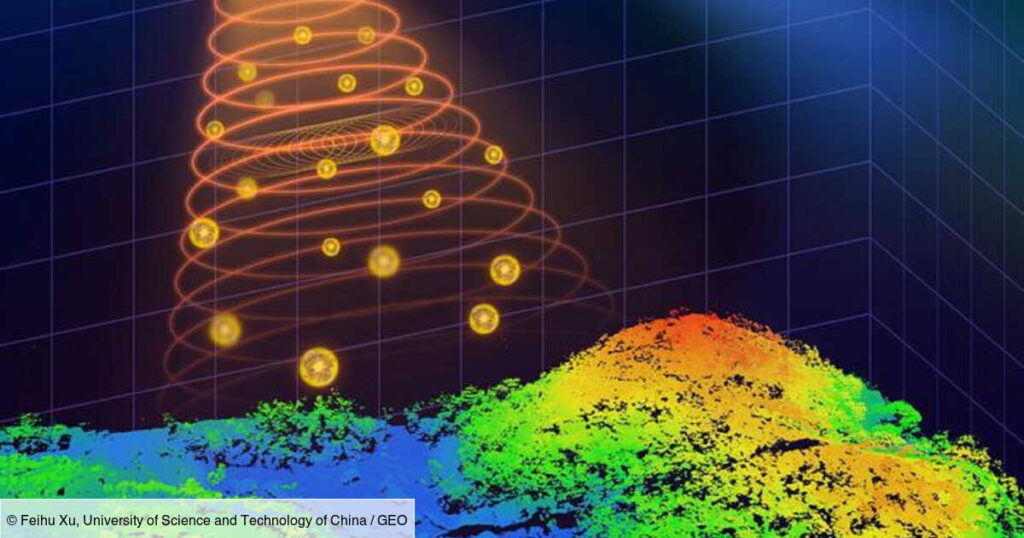
Information of a similar nature was brought to our attention in a press release relayed on Thursday April 25, echoing a study published the same day in the journal Optica. We learn that researchers from the University of Science and Technology of China have developed a single-photon airborne lidar system that is compact, but also lightweight and capable of acquiring high-resolution 3D images with a low-power laser.
The rest under this advertisement
Nature takes its time…
like this ad!
If this advance delights specialists, it is because it could allow them to use this device when they have to carry out missions related to environmental monitoring, 3D terrain mapping or Object identification.
Track deforestation and guide rescuers after an earthquake
Single photon lidar uses single photon detection techniques – a key element in the development of quantum technologies, where the signal resulting from a quantum calculation can be limited to the emission of a single photon – in order to measure the time it takes for laser pulses to travel to objects and back.
Such lidar is particularly useful in airborne applications, because it makes extremely precise 3D mapping of terrain and objects possible, even in difficult environments, such as urban areas or areas invaded by dense vegetation. .
The rest under this advertisement
Nature takes its time…
like this ad!
Nature takes its time…
like this ad!
“We have integrated recent technological developments into a system that, in comparison with other state-of-the-art airborne lidar systems, uses the lowest laser power and smallest optical aperture while maintaining good performance in terms of detection range and imaging resolution”explains Feihu Xu, from the research team at the University of Science and Technology of China, in the press release.
“In summary, our work has the potential to improve our knowledge of the world around us and contribute to a more sustainable and understandable future for all”, he rejoiced. This system could be “deployed on drones or small satellites to monitor changes in forest landscapes, such as deforestation“. We can also envisage it being mobilized after an earthquake, to generate 3D terrain maps in order to assess the extent of the damage and guide rescuers.
The rest under this advertisement
Nature takes its time…
like this ad!
Concretely, how does this new system work?
If we go into detail, we discover that this single-photon airborne lidar system will send light pulses from a laser towards the ground. These different pulses will bounce off the objects, before being captured by very sensitive detectors called “single photon avalanche diode arrays”.
These detectors will guarantee increased sensitivity to single photons, allowing detection of reflected laser pulses sufficiently precise that a low power laser can be used.
The information that scientists receive will, secondly, be screened by computer imaging algorithms. 3D images will then be constructed, reflecting the reality on the ground. “A key element of the new system is the special scanning mirrorsenlightens Feihu Xu. They perform a fine, continuous scan, capturing information (very precise) ground targets.”
The rest under this advertisement
Nature takes its time…
like this ad!
Nature takes its time…
like this ad!
To verify the effectiveness of its system, the team conducted tests, on the ground and on board a small plane. From now on, its efforts will focus on improving the system's performance and its practical implementation. The ultimate objective would be to install it on a space platform, like a satellite. Finally, before considering commercializing this system, it will also be necessary to improve its stability, durability and profitability.